Pilot Notes
When sailing the Andaman Sea it is critical to pay close attention to the wind and tides. Tides have a 3 meter (10 ft) range. Flow direction and rates are marked on the charts and currents vary from 0.1 knots to 2.2 knots (the strongest current, which you will experience when the tide drops 0.7 meters in one hour). There can be strong currents on the approaches to, and also in, the Ao Po Grand Marina of up to 2.0 knots on the flood and 3.0 knots on the ebb.
Always be careful when swimming from the boat while at anchor. If there is a current it is advisable to tie a fender or PFD to a mooring line and trail it behind the boat. November to April is the drier season and the prevailing wind blows from the northeast at 10 to 15 knots (known as the NE Monsoon) with generally calmer seas. However in the event of a significant change in wind direction and strength we will make adjustments to the itinerary to ensure the safety of flotilla participants as a first priority.
You must keep a sharp eye out for finishing nets and pots, which are numerous across our cruising grounds. Each boat must have crew on watch for hazards in the water. A finishing net wrapped around your propeller could end your charter early and you will be charged a significant amount of money by our charter company to bring the boat back into working order.
For those without water makers, or in the event of a water maker failure, the main places you will be able to refill water tanks within our sailing area are Koh Phi Phi Don, Port Takola Marina or Krabi Boat Lagoon, as well as Phuket Boat Lagoon/ Royal Phuket Marina, Yacht Haven, and Ao Po Grand Marina.
These pilot notes are originally sourced from the online Southeast Asia Pilot for Thailand, available here, and adapted by The Moorings. The chart images are sourced from The Moorings.
Ao Po Grand Marina
08º 04.00N, 098º 26.80E
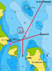
When departing the marina you must steer a course of 080º for 1.5 miles to a waypoint at 008º 04.30N, 098º 28.20E. On your return start from the same waypoint and steer 260º into the marina. Call the base on channel 72 or the base support number when at the outer waypoint to let us know you are coming in.
Beware that a strong tide can be present and be sure it is not pushing you off your track and into danger
Beware of the reef 20 meters off the entire length of the south pontoon of the marina
Be aware of the very dangerous reef half a mile to the north east of the marina (Hin Klang 08º 04.5373N, 098º 27.0973 E) which has a red buoy on its east side
There is also a shallow reef on the north side of Ko Nakha Yai
Ko Hong
08º 13.60N, 098º 30.10E
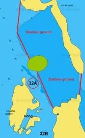
Anchor in the channel between the three islands (32A) in 12 meters being careful of the shallow water on the east side of the channel between Koh Yai and Koh Na Khae. Alternatively anchor on the south side of Ko Hong (32B) in 4 to 5 meters close to a tunnel which has all tide access leading to the main hong. There is a ranger station on Ko Yai and as soon as you anchor they will approach you for a fee of 500 THB per person and it is valid for 5 days and includes James Bond Island.
The main hong is accessible by dinghy at any state of the tide but is best visited at high tide. Leading from the west side of the main hong is a small tunnel to another two smaller hongs. You can only enter them by sea kayak at mid-tide.
Be aware of the strong current in the channel between the islands
Ko Phing Kan (James Bond Island)
08° 15.98N, 98° 30.06E
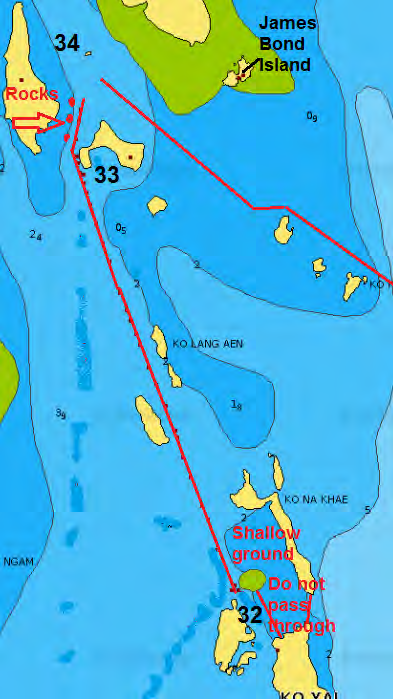
To navigate from the anchorage at Ko Hong steer a course of between 335º and 340º to pass between Ko Sa Kang and Ko Lang Aen. Once the small island north of Ko Yang comes fully into view you can continue north keeping Yo Yang to starboard then turn due east, then south east to anchor in 3-5 meters south west of Ko Phing Kan
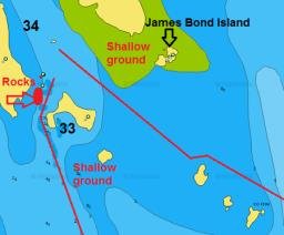
When approaching from the south along the channel from Koh Hong be aware that the channel is much narrower than shown on the chart 333 and has drying patches on either side that are not shown on the chart
Do not cut across the south side of Ko Yang - there is an uncharted shallow bank south east of the bay
Be aware of the uncharted rock off the eastern point of Ko Daeng Yai at approximate position 008º 16.25N, 098º 29.15. It lies just under the surface at low tide and has been hit many, many times. Beware!
There is a strong current when the tide is on the ebb
The best point to go ashore at Ko Phing Kan is on the south west side where you can access the lagoon at the back of the island by the footpath. When leaving this anchorage via the south east passage start just south of the rock pinnacle in the middle of the channel and steer for the north point of Ko Lo Lo by keeping it in transit with the north point of Ko Khai just behind it. Turn east when you reach Ko Lo Lo to keep clear of the shallow bank north of Ko Khai.
Ko Roi
08º 11.55N, 098º 36.55
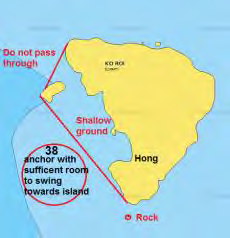
Anchor on the west side of this beautiful island to the south of the rock stack in 8 to 12 meters.
Do not attempt to pass between the rock stack and Ko Roi
Do not approach any closer than a line drawn from the headland to the stack
Allow sufficient room to swing on anchor
Be aware of the shallow reef across the entire east side of Ko Roi
There is a concealed rock off the southern point. Keep well clear
Rai Le Beach, Krabi
08º 00.65N, 098º 49.85E
Anchor in 4 to 5 meters well offshore on a sandy bottom.
Do not anchor closer than a line drawn from the two islands Ko Nang to the northwest headland
Krabi Boat Lagoon Marina
08° 0.70N, 98° 57.67E
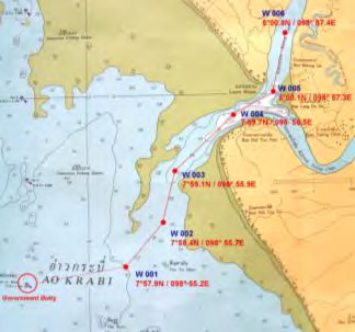
This marina has been built up a shallow river. From the entrance waypoint, at high tide, carefully follow the waypoints in. When the marina is visible on your starboard side, call on channel 67 for instructions on docking. This is a great place to refill your water and diesel. If time (and tide!) permits, you can take a 30 minute taxi to the Tesco Lotus supermarket near Krabi town to restock provisions.
Must enter and leave on a high tide
Kantiang Bay, Ko Lanta
07º 29.60N, 099º 04.10E
Anchor close inshore in 5 metres on a sandy bottom at the south end of the beach opposite the Pimalai Resort and Spa, a 5-star resort nestled amongst the foliage against the beach. Visiting yachts are welcomed BUT may use the floating jetty at the north end of the resort ONLY if they intend to use the resort restaurant. The jetty is dismantled and taken away at the end of each high season. The original parts of the jetty are black and can get scorching hot in the midday sun. Tie close to the beach and wear shoes.
The floating jetty belongs to the Pimalai Resort and Spa, and is strictly private. Only tie to the jetty if you are using the restaurant
Ton Sai Bay, Ko Phi Phi Don
07º 43.80N, 098º 46.40E
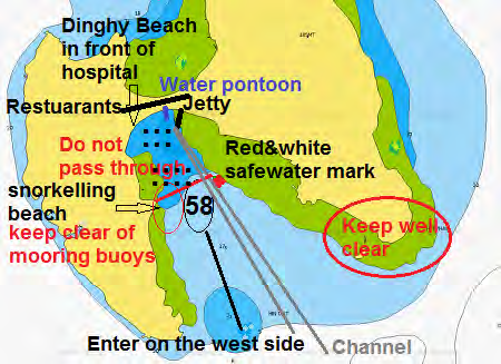
Anchor south of red and white channel marker, well away from the numerous moorings in 10 to 13 meters. There is a small bay just inside the southern tip of Ton Sai, which is generally quieter. When going ashore head for the dinghy landing beach left of the water pontoon in front of the hospital. It is better to enter after 17h30 to avoid the water traffic heading for the pier. It is best to leave the anchorage by 09h30 before it starts again.
Pay close attention to your chart plotter and depth sounder and enter the bay on the west side only. The whole length of the east side is a large reef
Take care to give sufficient swinging space to any of the moorings, some of which are slightly submerged
Also take care to avoid the reef on the west side of the bay which rises vertically from 15 meters to almost dry out at low water
Depths decrease suddenly from over 20 meters to under a meter at the edge of the reef
Do not pick up one of the moorings under any circumstances, they are all private and you will have a visit from the irate owner during the night
Do not leave the dinghy against the rock wall as it will get damaged
Only bring a monohull alongside the pontoon for water at high tide, fill up then go back out to the anchorage
It is best not to swim off the back of the boat due to the anchorage being heavily trafficked
Take care embarking and disembarking the dinghy due to wake from passing vessels at very high speed
Ko Phi Phi Le
07º 40.75N, 098º 45.85E
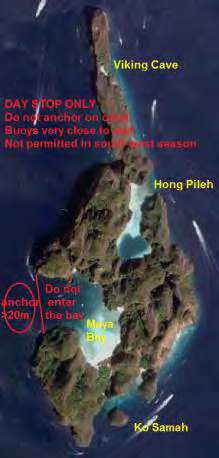
Known as Ko Phi Phi Le this island is marked as Ko Phraya Nak on Thai chart 308. There is a large shallow reef across the southern half of Maya Bay so you must stay close to the north side where there are five National Park mooring buoys which can be used by yachts, but only with extreme caution as there are numerous coral heads. Dropping anchor anywhere on, or even near, coral in the park is illegal and carries a heavy fine. If a mooring is not available you must anchor the yacht outside the entrance to the bay in no less than 20 meters. If you go ashore to the beach you will be charged a national park fee.
On the south east tip of Phi Phi Le you will see a small island Ko Samah with a channel behind it filled with great coral. It is suitable as a lunch stop only although it is very busy. There is a cave and tunnel that leads to Maya bay.
In the middle of the east side of Phi Phi Le you will see Hong Pileh. This beautiful lagoon has a very shallow entrance and extends into the island some considerable distance. It is not possible to enter in the yacht, and due to the deep water outside the lagoon anchoring is difficult. It is advisable that two crew stay on the yacht and stand off to allow the rest of the crew to visit by dinghy. At the back of the hong the water is much deeper and great for a swim.
To the north of Hong Pileh is Viking cave. This is a site for collecting swallow nests to make birds nest soup. The collectors actually live in the cave and in recent years have not allowed visitors to enter the cave. There are no restaurants on Ko Phi Phi Le.
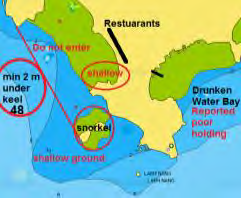
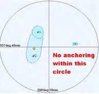
Protected dive site: To avoid damaging the coral it is strictly prohibited to anchor within 1.5 miles of position 07º 4.0N, 98º 38.0E (see diagram above)
Given the many restrictions and deep water necessary to permit anchoring you are strongly advised to take a long tail boat from Ton Sai Bay when visiting Ko Phi Phi Li. Long tail; trips will visit Maya Bay and Hong Pileh.
Loh Paret Bay
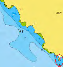
07º 59.00N, 098º 33.85E
Easy anchorage, no hazards. Anchor in 7 to 10 meters in the small bay just south of the concrete pier which belongs to the Santhiya Resort & Spa on the headland to the north.

